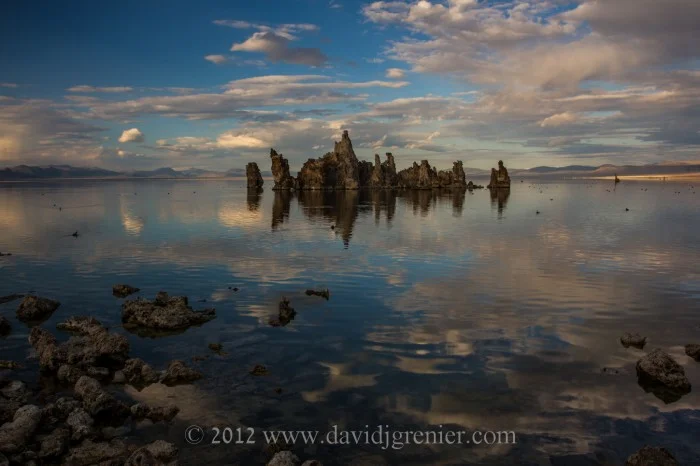
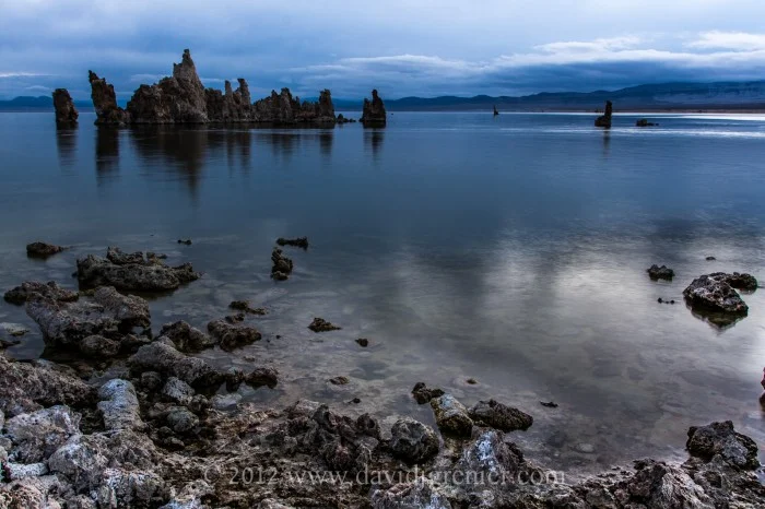
Fine Art Photography
_24A8061-Edit.jpg

Blog

David J Grenier Fine Art Photography Blog Pages

diVittorio Winery Tasting Room Gallery, January 2013
P1010995-1-700x525.jpg

I am pleased to announce that some of my photography is on display at the diVittorio Winery Tasting Room in Camino, California. I have very generously been given permission, by the owner's of the Winery, to set up a small gallery of my images, so that visitors will be able to view and purchase matted prints of a selection of my work.

The diVittorio Winery Tasting Room is located at - 3500 Carson Road, Camino, California. Their phone number is 530-621-2166. Their website is http://divittoriowinery.com/  They have a wonderful selection of red wines and award winning ports that are well worthwhile stopping by to sample at their spacious tasting room, Wednesdays through Mondays, and to view and/or purchase my photography in person. Looking forward to your visit sometime soon!

P1010988-1-700x525.jpg
Native American Portraits, January, 2013
I92C0950-1-2-700x466.jpg
I92C1092-1-2-600x900.jpg
I92C1095-1-3-2-600x900.jpg

It was an honor and my pleasure to recently participate in an Arizona Highways Magazine photo workshop at The Heard Museum of Native Cultures and Art, Phoenix, Arizona. It was my first experience working with Navajo people in a photo shoot setting and my initial exposure to their colorful and detailed ceremonial dress.

It was an experience that I enjoyed a great deal and would like to spend more time pursuing further. As a traditional, mostly landscape photographer, venturing into the work of portraits is something that I have wanted to do for sometime now. I could not be more thrilled and motivated to continue this activity after attending this workshop.

Enjoy!

Zion National Park, November 2012
IMGL4185-1-2-700x456.jpg
IMGL4337-1-2-700x466.jpg
IMGL4144-1-2-700x466.jpg

After visiting Bryce National Park at the end of October, 2012, on the way back I had the good fortune of visiting the magnificent  Zion National Park for a couple of days as well.

A prominent feature of the 229-square-mile (590 km2) park is Zion Canyon, which is 15 miles (24 km) long and up to half a mile (800 m) deep, cut through the reddish and tan-colored Navajo Sandstone by the North Fork of the Virgin River. Located at the junction of the Colorado Plateau, Great Basin, and Mojave Desert regions, the park's unique geography and variety of life zones allow for unusual plant and animal diversity. Zion National Park includes mountains, canyons, buttes, mesas, monoliths, rivers, slot canyons, and natural arches.

Human habitation of the area started about 8,000 years ago with small family groups of Native Americans. Mormons came into the area in 1858 and settled there in the early 1860s. In 1909, U.S. President William Howard Taft named the area a National Monument to protect the canyon, under the name of Mukuntuweap National Monument. In 1918, however, the acting director of the newly created National Park Service changed the park's name to Zion. According to historian Hal Rothman, "The name change played to a prevalent bias of the time. Many believed that Spanish and Indian names would deter visitors who, if they could not pronounce the name of a place, might not bother to visit it. The new name, Zion, had greater appeal to an ethnocentric audience."

IMGL4455-1-2-600x900.jpg
IMGL4468-1-2-700x466.jpg
IMGL4566-1-2-700x466.jpg

The Narrows in Zion National Park, is a section of canyon on the North Fork of the Virgin River, that is a longest slot canyon in the USA. The hike of The Narrows is one of the premier hikes on the Colorado Plateau. The term The Narrows refers to both the through-hike of The Narrows, and to The Narrows themselves, especially the 3.6 miles (5.8 km) long section of canyon between the end of the Riverside Walk Trail and Big Spring.

Hiking The Narrows was the highlight of this trip. We managed to complete the hike, through waters up to our knees at times, in just under 7 hours. It was a particularly arduous task for me as I had the physical handicap of having blisters on both my feet from hiking Bryce Canyon for a couple of days, and had fallen and badly scraped both my knees on a night photo shoot the day before. It was still a memorable experience and accomplishment, and resulted in the images above.

Enjoy!

Bryce Canyon National Park, November, 2012
IMG_0864-11-700x524.jpg
IMGL3741-1-700x466.jpg
IMGL3923-12-700x466.jpg

I visited Bryce Canyon at the end of October, 2012. I was astounded to see this magnificent site the first time I laid my eyes on the hoodoos that make up this unique canyon.

Bryce Canyon National Park is located in southwestern Utah about 50 miles (80 km) northeast of and 1,000 feet (300 m) higher than Zion National Park.  The rim at Bryce varies from 8,000 to 9,000 feet (2,400 to 2,700 m). The major feature of the park is Bryce Canyon, which despite its name, is not a canyon but a collection of giant natural amphitheaters. Bryce is distinctive due to geological structures called hoodoos, formed by frost weathering and stream erosion of the river and lake bed sedimentary rocks. The red, orange, and white colors of the rocks provide spectacular views for park visitors.

Bryce Canyon area was settled by Mormon pioneers in the 1850's and was named after Ebenezer Bryce, who homesteaded in the area in 1874. The area around Bryce Canyon became a National Monument in 1923 and was designated as a National Park in 1928. The park covers 35,835 acres (55.99 sq. miles; 145.02 sq. km) and receives relatively few visitors compared to Zion National Park and the Grand Canyon, largely due to its remote location.

What caught my eye at Bryce are the hundreds of bright colored hoodoos, which in sunny afternoon light appear to glow and have an iridescent quality to them. As the sun moves over the various amphitheaters from sunrise to sunset, the colors of the hoodoos change and create a never ending pallet of colors that are magnificent and simply delightful to watch.

The first image above was taken with my iPhone. Upon arrival in the afternoon, I walked to the canyon having made the decision that we did not need to take our camera gear with us, as we were 'just going up there to see Bryce for the first time and get oriented'. I never saw these same colors and iridescence again, but did capture the sunrise and the sunset images also shown above with my 'big boy' camera equipment.

Mono Lake, An Ancient Sea - Part II
IMGL3073-700x466.jpg

'Kiss The Sky'

IMGL3099-700x466.jpg

'Shipwreck In Paradise'

IMGL3121-700x466.jpg

'Mono Lake Sunset'

I wanted to post a few images from my recent photo shoot to Mono Lake and also write some more about this amazing place. I will do that by continuing to quote from the California State Parks brochure that I bought at the South Tufa Area.

To begin with I wanted to mention how grateful I was for the beautiful skies that we enjoyed during our visit. Clouds make such a difference to a landscape photographer in that they provide that additional element to a photograph that adds color, interest and simply makes an image all that more aesthetic. In meteorology, a cloud is a visible mass of liquid droplets or frozen crystals made of water or various chemicals suspended in the atmosphere above the surface of a planetary body. The international cloud classification system is based on the fact clouds can show free-convective upward growth like cumulus, appear in non-convective layered sheets such as stratus, or take the form of thin fibrous wisps, as in the case of cirrus.

A major conservation effort to save Mono Lake was waged for many years, and I am sure that at some point somewhere in California you would have seen a ‘Save Mono Lake’ bumper sticker. To quote from the State Parks brochure: “In 1941, the City of Los Angeles began diverting streams that feed Mono Lake. The diversion of those streams caused Mono Lake to drop more than 40 feet, exposing about 17,000 acres of ‘recession’ lands. Recession lands are the exposed lakebed lands below the elevation of 6,417 feet above sea level, where the lake surface was in 1941 before diversions began. Concerns were raised about the lake’s ecosystem, the effects of wind-blown alkali dust on Mono Basin air quality, and the aesthetics of a shrinking lake. Citizens groups – The Mono Lake Committee and the National Audubon Society – began legal efforts to protect Mono Lake.

On September 28, 1994, after 16 years of court battles, research and hearings, the State Water Resources Control Board issued an order to protect Mono Lake and its tributary streams. The effects of the order will ultimately raise the level by 17 feet to an elevation of 6,392 feet above sea level over the next 15-20 years. All parties involved agreed to accept this plan and implement it in a spirit of cooperation.

While the lake may be saved on paper, much remains to be done. Stream and waterfall habitat restoration effort are still underway, with input from the U.S. Forest Service and Reserve staff and the Mono Lake Committee. The question today is not whether Mono Lake will be saved, but how it will be saved.”

We the People, on occasion are still heard and can effect change when we come together for a worthwhile cause!

Enjoy..........

Fall Color Abstracts, Bishop Canyon, California

I have always enjoyed abstract art. My first introduction to abstract art was seeing, and being struck by Salvador Dali’s 1931 painting ‘The Persistence of Memory’ – it’s the one with the melting clocks. My initial reaction to this piece of art was profound, disturbing, thought provoking, yet enjoyable somehow. It left me with an indelible impression of the uniqueness and creativity that Dali brought to the world of art. Abstract art requires both the artist and the viewer of the art to think outside the box. It requires you to move away from reality and enjoy what’s different. It is creative both for the artist and the viewer of the art. One of my most cherished possessions in this life is a Dali original colored woodcut titled ‘Divine Comedy’, which proudly hangs in my living room today. This fondness for abstract art was recently rekindled when I met a photographer who has a leaning towards the abstract. Her creations are unique in the methods used to produce the images, as well as the final results. I have also been drawn to creating abstracts from what I see in nature, though until recently, these have remained just thoughts in my mind. Going through her portfolio of images inspired me to act on these thoughts during my recent fall colors field trip to the 'backside of the Sierras'.

As a landscape photographer I am well aware that just about everything that there is available to capture with a camera has already been done by someone else – just my opinion. What is left that is unique is one's own composition and the conditions given to you by Mother Nature on any given day or occasion. At the risk of over simplifying a fairly comprehensive subject, as a landscape photographer there are some basic elements required to create a good image – sharpness of the subject, good composition, and the timely  capturing of color and light. When one ventures into the abstract the idea is to somehow find a different interpretation of Mother Nature and reality, which requires thinking outside the box and developing methods and techniques that can produce an image that evokes a reaction and provokes thought outside the well know and recognized paradigms of landscape photography.

The three images below are my first attempt at creating abstract art as a photographer. The first couple of images are created by the movement of my camera while its shutter is still open. The third image was the bringing together of available color, movement and natural elements that are both abstract and real. I am pleased with these first attempts and hope to be able to refine and hone these techniques with time and the blessings of my Creative Muse. Enjoy!

IMGL3316-700x466.jpg

'Aspen's Dance'

IMGL3325-700x466.jpg

'Quivering Aspens'

IMGL3411-700x466.jpg

'Multicolored Lady'

Mono Lake, An Ancient Sea - Part I
IMGL2705_HDR-700x470.jpg
IMGL2745-700x466.jpg
IMGL2757-700x466.jpg

Currently as I write this blog, it is raining and snowing in June Lake, approximately 15 miles from Mono Lake. I went out on a sunrise shoot this morning where it was 28° F at 6:00 am at the South Tufa area. When I drove into the parking lot at that time there were about 20 plus cars already in the parking lot – this place was grand central station this morning with photographers in the area for fall color workshops etc. etc.

Here’s some background on Mono Lake from the State Park brochure. “Mono Lake is a majestic body of water covering about 60 square miles. Estimated to be over a million years old, Mono is one of the oldest lakes in North America. Throughout its long, existence, Eastern Sierra streams have fed Mon Lake with fresh water laden with salts and minerals carried down from the mountains. With no outlet, water can only leave the basin through evaporation, and the salts and minerals are left behind. As a result, Mono Lake is two and a half times as salty and eighty times as alkaline as ocean water.”

“Mono Lake’s tufa towers (pronounced “toofah”) are spectacular examples of what nature can do with a few basic elements. Their unusual spires and knobs are formed when calcium-bearing freshwater springs well up through alkaline lake water, which is rich in carbonates. The calcium and carbonate combine precipitating out as limestone. Over many years, a tower forms around the mouth of the spring. The tufa-forming reaction happens only in the lake itself. As the lake level drops and exposes the tufa towers, they cease to grow.”

The images above were shot yesterday evening and one this morning. Enjoy!

Jet Lag and The Fall Colors Photo Shoot, October 2012
MG_2114-603x900.jpg
MG_2205-600x900.jpg
MG_23711-600x900.jpg

I have been back from Australia for just over a week now and I am finally and just about completely over the inevitable jet lag from an overseas trip. From Wikipedia “Jet lag is a physiological condition which results from alterations to the body's circadian rhythms resulting from rapid long-distance transmeridian (east–west or west–east) travel on a jet aircraft. The common term 'jet lag' is used because before the arrival of the passenger jet aircraft, it was generally uncommon to travel far and fast enough to cause jet lag. Propeller flights were slower and of more limited distance than jet flights, and thus did not contribute as widely to the problem.”

It seems to me that the jet lag that hits me is less apparant when I go to Australia than it is when I arrive back home. In Australia I seem to wake bright eyed and bushy tailed early in the morning, which works well as I am usually on the beach at 5:00AM waiting to photograph the sunrise over the ocean in Currumbin. Staying awake past 9:00PM at night usually is a challenge and the afternoons require a hit of 5-Hour Energy, my choice of ‘stay-awake’ elixir. My experience being back home is the opposite, in that waking up in the morning is similar to being in a heavy mental fog until about 10:00AM, where as I can stay awake at night until the wee hours of the morning!

I am getting ready to leave on my annual trek to photograph the beautiful fall colors along Highway 395 in California. We are initially headed to Mono Lake and the surrounding Lundy Canyon and June Lake, then head further south to the Bishop area, where the Aspen trees turn beautiful and wondrous colors of yellow, orange and gold. We also stop off in Shulman Grove to photograph the amazing Bristlecone Pines, with some of the trees being over four thousand years old!

I have posted a few images from last year's trip to give you an idea of the beauty encountered along this marvelous journey. Enjoy!

Natural Bridge, Naminbah Valley, Queensland
IMGL1940_HDR1-700x466.jpg
IMGL1963_HDR1-700x466.jpg
IMGL1992_HDR1-700x466.jpg

I first visited Natural Bridge about 20 years ago, together with my kids and my cousin’s kids. We all had a wonderful time getting to see the various rock formations, stroll along the rain forest paths, picnic in the surrounding grounds and swim in the chilling waters of the cavern's recesses. These days the whole area has changed and the river waters are no longer accessible to visitors, having been fenced in completely, leaving three viewing platforms and well-constructed walking paths through out.

"The Natural Bridge was formed at the junction of one basalt layer and a softer volcanic layer beneath called agglomerate.  The lower, softer layer was undercut at the base of a waterfall, forming a deep cavern.  At the same time, the circular motion of boulders in the stream above had formed a deep pool.  The drilling action deepened the pool until it broke through the cavern roof, allowing the stream to plunge through the hole and out through the cave below.

Behind the Bridge the mountain-fed waters of Cave Creek form a waterfall which plunges through the roof of a cave into a sparkling pool below, which then flows into the Nerang River and down the Numinbah Valley.  Surrounding the creek is dense sub-tropical rainforest.

Once home to the Kalibah Aboriginal people, the Natural Bridge area remained untouched by European settlement until it was discovered by timber-getters, probably in 1893. Magnificent trees felled in the area included a giant red cedar taken in 1893 from near Natural Bridge.  A huge section of this was displayed at the Paris World Fair."

I was recently driven out to Natural Bridge by that same cousin, this time minus the kids, who are now all grown. The images above were captured during that visit. They are the result of bracketing three RAW files, blended together using the NIK Software HD Efex Pro 2, and final development in Adobe Lightroom 4.

Currumbin Rock ~ Color or Black and White?
MGL1125-700x466.jpg
MGL1125-Edit-2-700x466.jpg

I was lucky enough to be given a beautiful sunrise at Currumbin a couple of days ago. It included a beautiful cloud filled sky, a high tide and no wind, a perfect combination for a colorful sunrise.

As a photographer, in the post development phase of ‘making a photograph’ to quote the great Ansel Admas, you then have to decide, color or black and white?

The color image above was developed in Adobe’s Lightroom. The black and white image was developed using NIK Software’s Silver Efex Pro 2.

You decide?